Dunes Docks and The Vanderbilt
Channel of the Cocohatchee River
Update: March 9, 2015: To quote the cliche, "No news is good news." Since 2012, there has been no new news concerning the proposed marina that Lodge Abbott Associates LLC (aka. Vanderbilt Partners II Ltd) (aka Signature Community) wanted to build adjacent to the Dunes Community. It appears that the development company has backed off of its attempt to build a marina, or at least we aren't hearing about it. The process of their trying to obtain permits began in 2002. Apparently, the process ended March 1, 2012 with the Collier County Planning Commissioners' 4/5 vote opposing construction of the dock extension of 49 slips along Vanderbilt Channel. Reasons for the vote: safety concerns and the need to protect sea grass and wildlife.
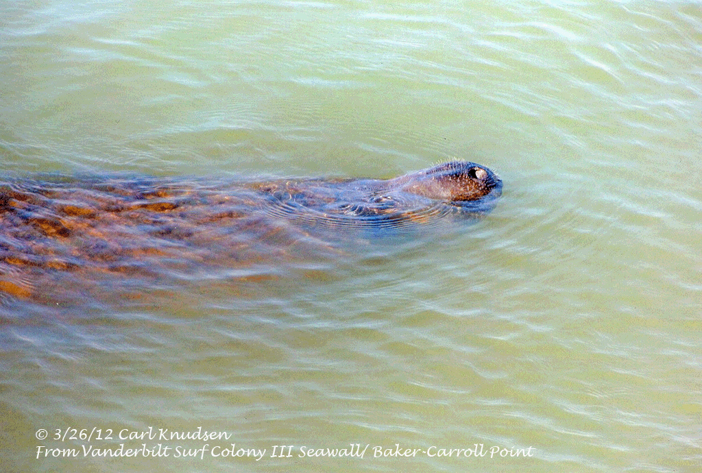
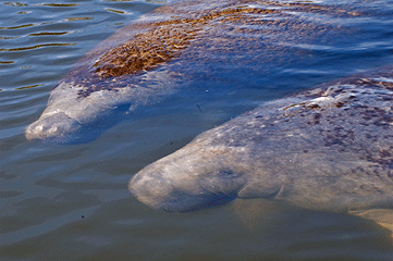
Shortly after the Collier County Planning Commissioners meeting, manatees were seen in large numbers in the channel. They seemed to be celebrating the victory of their habitat's protection. Below is a history of some of the manatee sightings:
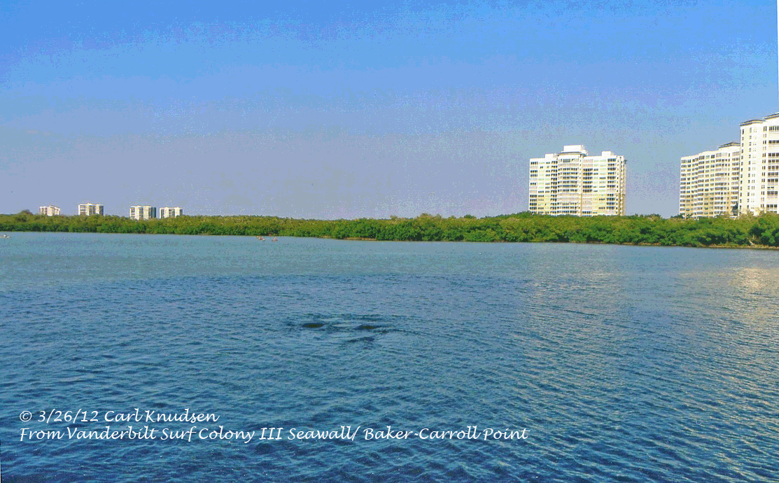
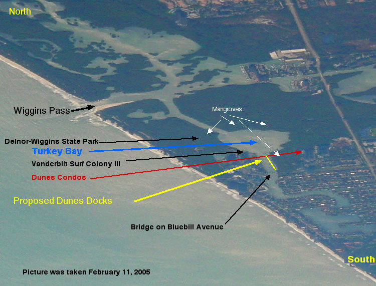
Report dated April 8, 2012: For the last two weeks, a breeding herd of manatees have been spotted in the Cocohatchee River in Water Turkey Bay, the Vanderbilt Channel, and the Vanderbilt Lagoon. Many people living adjacent to the Vanderbilt Channel were fortunate to see the herd on March 26th at the northern-most point of Baker- Carroll Point and Water Turkey Bay.
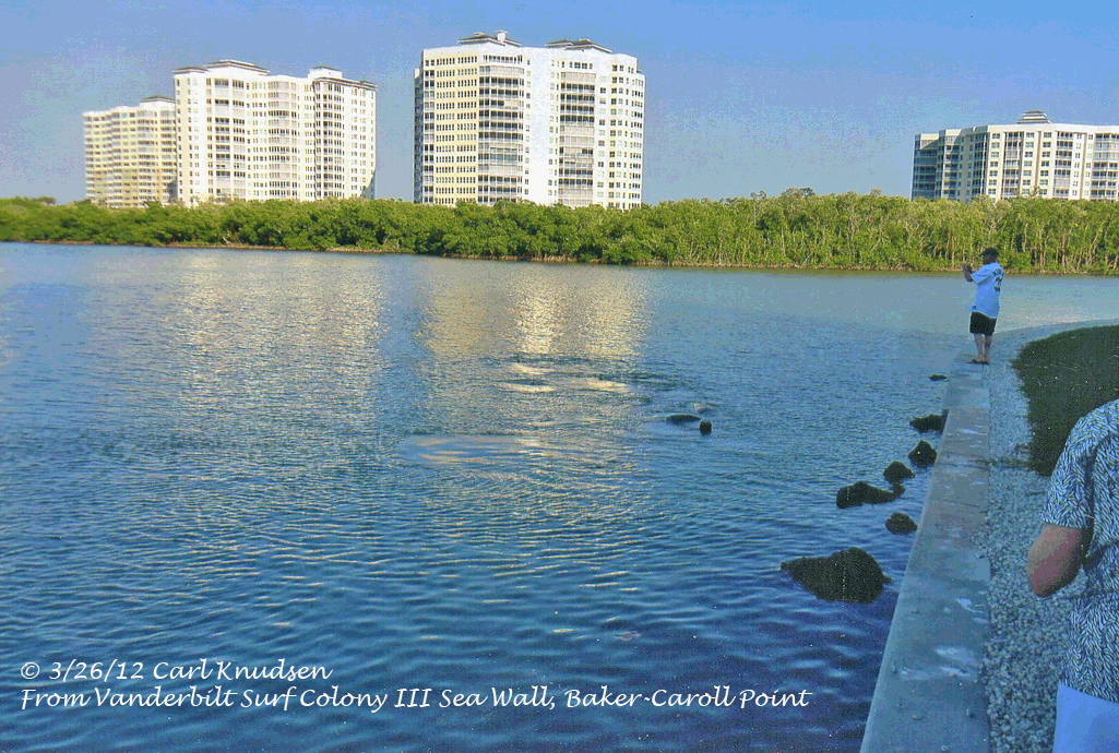
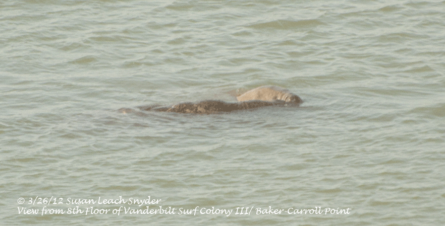
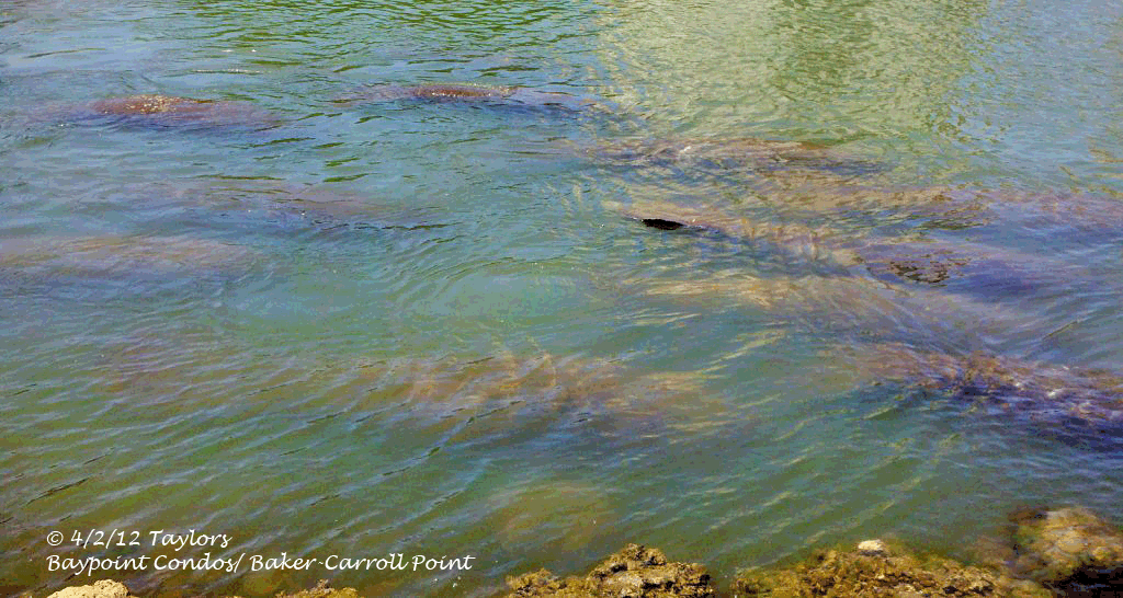
On March 29th, several people reported seeing the herd in the middle of the Vanderbilt Channel adjacent to Baker-Carroll Point. On April 1st, a manatee was observed in the Vanderbilt Lagoon. On April 2nd the photographs below were taken at the southern end of the Vanderbilt Channel (Baker-Carroll Point), just north of the 111th street bridge.
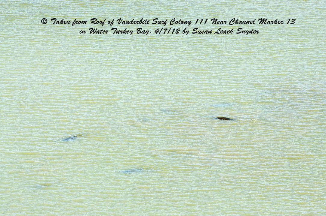
Manatees have been reported traversing the waters from Wiggins pass to the Vanderbilt Lagoon. On April 7th they were spotted again at Water Turkey Bay and also on April 7th and 8th in the Vanderbilt Lagoon.
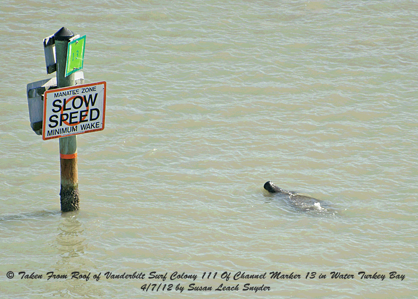
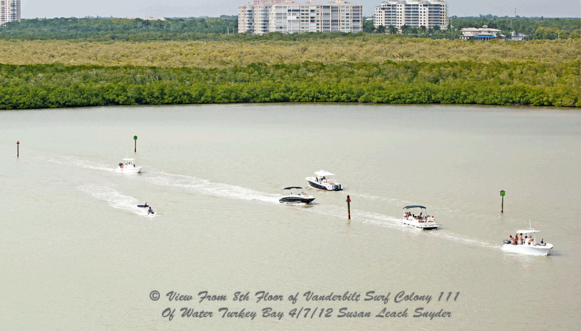
Today (2015), boats and waverunners continue to use this waterway at fast speed ... even though Water Turkey Bay, the Vanderbilt Channel and the Vanderbilt Lagoon are No Wake/ Idle Speed Zones according to County Ordinance. The sign shown above isn't correct. In Water Turkey Bay, the speed is "No Wake," but the County and Fish and Wildlife have yet to make the sign correction, despite letters and phone calls to both over the years. But even with the posted "Slow Speed", many boaters ignore the sign. "Slow Speed" means minimal wake with the boat totally settled in the water. As shown below, most boats and waverunners are in excess of this speed.
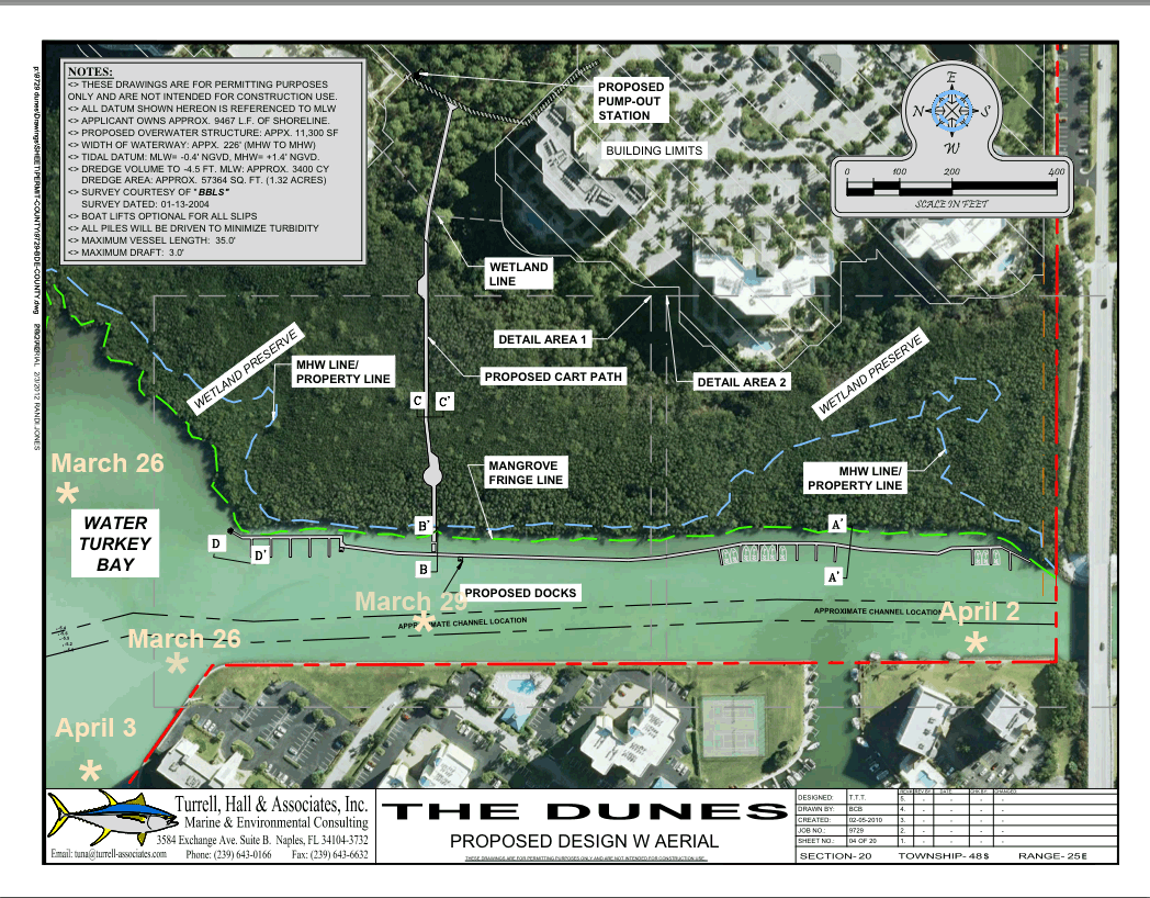
It is only a matter of time before there are manatee fatalities in these waters. Now, consider where the proposed location of the Dunes Docks Marina was to be. The drawing below shows the location. Superimposed on the map are the sightings of manatees from March 26-April 8th, 2012 that were in the boundaries of the drawing. The drawing is misleading because it does not show all of the 49 boats. Many would be moored parallel to the boardwalk.
In regards to these docks, two issues were decided at the Collier County Planning Commission on March 1, 2012. The first was to determine whether Vanderbilt Partners II Ltd. could add a multi-dock facility (i.e. marina) to its Planned Unit Development map, and have this addition be considered an insubstantial change. The original PUD map showed no such facility. The CCPC voted 5-4 that it was insubstantial. The second issue was whether or not the multi-dock facility proposal met enough required criteria to have a dock extension 261 feet beyond the 20 feet the county allows. The CCPS rejected the dock extension 5-4. The CCPC decided the placement of the facility would adversely affect the only seagrass beds in the region, and interfere with navigation and the public view of the river. The proposed facility would have created a wall of boats standing 15 feet high and stretching 1/4 mile. It would have blocked 1/4 of the narrow Cocohatchee Channel. Without the dock extension, the developer cannot build the multi-dock facility. The next step was for "Signature" to appeal the CCPC decision to the Collier County Commissioners. They had 30 days to do that. That date has come and gone. It is unknown what "Signature" will do next.
Besides those issues dealing with the boat extension of distance into the Cocohatchee River, there is the issue of the number of docks Vanderbilt Partners Ltd. II Communities, wanted permitted. As stated above, "Signature", wanted to build 49 wet slips. By law, only 28 could be built unless "Signature" could count its conservation easement land in the calculation. Collier County needs to decide how to best apply the Land Development Code that applies to the Manatee Protection Plan and Conservation Easements.
Below, you will find background information about "Signature's" Conservation Easement, the definition of "Conservation Easement", background information on the Manatee Protection Plan, facts about the Vanderbilt Channel and environmental threats to its well-being, and links to editorials and other documents.
_____________________________
Background Information about Signature Community's Conservation Easement
The Conservation Easement that Signature Communities wants to count in the shoreline calculation of wet slips is a mangrove forest north and adjacent to the Dunes Community. The mangrove forest was set aside because scrub habitat was destroyed in the process of building the Dunes development. The mangrove forest is an estuary. It is a nursery for fish and a rookery for birds. This forest could never be developed (even before it was set aside as a conservation easement) because mangroves are protected by state law.
The easement has been used by Signature three times to get favors from the government. The first time was as mitigation for scrub habitat destruction. The second time was to get an Environmental Resource Permit from the South Florida Water Management District to build the marina, and the third time was to get a Submerged Land Lease from the Board of Trustees of the Internal Improvement Trust Fund (i.e.. Governor Crist and his cabinet) to build the marina. Although Signature has not yet submitted its application to the County to begin construction of the marina, Signature wanted a 49-wet slip marina, not a 28 wet slip marina. If the conservation easement land could be counted in the wet slip calculation, Signature would be granted the larger marina.
Definition of "Conservation Easement"
According to Florida Statutes, Title Xl, Chapter 704.06, a “conservation easement” means a right or interest in real property which is appropriate to retaining land or water areas predominantly in their natural, scenic, open, agricultural, or wooded condition; retaining such areas as suitable habitat for fish, plants, or wildlife; ...” and it “prohibits or limits all or any of 8 things. One of these 8 is: f) Activities detrimental to drainage, flood control, water conservation, erosion, soil conservation, or fish and wildlife habitat preservation. Building a large marina adjacent to a conservation easement will definitely increase erosion and destroy fish and wildlife habitat.
Background Information about the Manatee Protection Plan
The management and protection plans for the West Indian Manatee in Collier County are set forth in section 5.05.02 of the Land Development Code, titled “Marinas.” Section C of 5.05.02 describes a rating system established to evaluate proposed marina facilities. The purpose of the marina site rating system is to help determine the maximum wet slip densities in order to improve existing Manatee protection. The marina site rating system gives a ranking based on three criteria: water depth, native marine habitat, and manatee abundance. In evaluating a parcel for a potential boat facility, a minimum sphere of influence for the boat traffic must be designated.
“A protected ranking is given to a site where: there is adequate water depth and access, but there is an impact to native marine habitat and there is an impact to a high manatee use area; there is not adequate water depth, there is impact to or destruction of native marine habitat, and there is impact to a high manatee use area; there is not adequate water depth, no impact to marine habitat, but there is impact to a high manatee use area; or there is not adequate depth, there is impact to marine habitat, and no impact to a high manatee use area.” The Dunes Docks marina would be built in shallow water that would have to be dredged. In the process of dredging and construction, there would be loss of native marine habitat. Doesn't this qualify this area as having a "protected ranking?"
_______________________________________
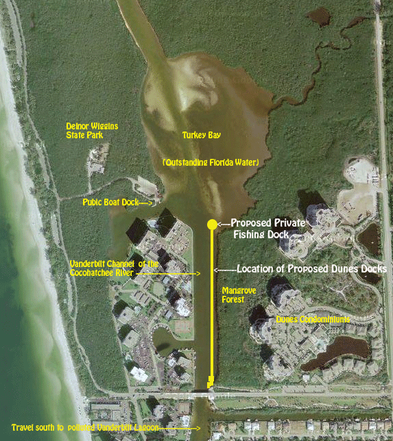
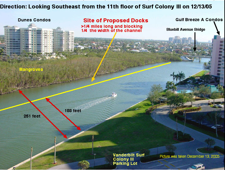
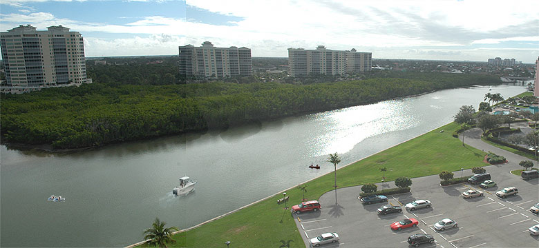
Facts: The location of the marina would have been in the Vanderbilt Channel of the Cocohatchee River between the 111th street bridge (Bluebill Avenue) and Water Turkey Bay, as shown in the aerial photograph below:
In order to build these docks and fishing pier, the developers had to obtain several permits:
1) "An Environmental Resource Permit (ERP) must be obtained before beginning any activity that could affect wetlands, alter surface water flows, or contribute to water pollution. (Source South Florida Water Management District website.) This was obtained.
2) They must get a submerged land lease from the state of Florida. The land they wish to lease belongs to the state, not to Signature Communities. In order to get the submerged land lease, they must get the Governor's Cabinet's approval for the lease. The Cocohatchee River is part of the Wiggins Pass Estuarine System, identified by the State of Florida as "Outstanding Florida Water." This designation guarantees the water will have special heightened protection from pollution. In order to permit the submerged land lease in this area, the Dunes property developers must prove that their project is “clearly in the public interest." This was approved June 9, 2009.
3) Signature Communities must receive a permit from the Army Corps of Engineers pursuant to Section 404 of the Clean Water Act and Section 10 of the Rivers and Harbors Act of 1899 in order to dredge during construction of the docks. This was obtained.
4) Signature Communities must receive a county permit to build the wet slips. This was never obtained.
Left: A satellite view of the Vanderbilt Channel and Turkey Bay shows North is at the top of the map. Note: condos on the east side of the Vanderbilt Channel are the Dunes, condos on the west side of the channel are those at Baker Carroll Point. Along the coast is Delnor Wiggins State Park. South of the location of the proposed Dunes Docks is Vanderbilt Lagoon, shown in the the satellite photograph below.
Clearly, the building of docks in the Vanderbilt Channel is not in the public interest for the following reasons:


-
1) Impact on Water Quality: As stated earlier, the Cocohatchee River is part of the Wiggins Pass Estuarine System, identified by the State of Florida as "Outstanding Florida Water." This designation guarantees the water will have special heightened protection from pollution. In order to permit the submerged land lease in this area, the Dunes property developers must prove that their project is “clearly in the public interest.” At a South Florida Water Management District Governing Board meeting on December 14th, 2005, the developers' lawyer’s “proof” that the project is "clearly in the public interest" was that they will be paying a fee to lease the submerged land, and once this particular submerged land is developed with docks, other mangrove property they own along the Vanderbilt Channel will be protected from further development.
In the 2005 Estuaries Report Card for Southwest Florida, a study conducted by scientists at the Conservancy of Southwest Florida, the Wiggins Pass/ Cocohatchee Watershed was found to have a Wildlife Rating of B- and a Water Quality rating of C-. By comparison, Naples Bay Watershed, a highly developed watershed had a Wildlife Rating of F- and a Water Quality rating of C-.
In 2007, the Federal Water Resources Development Act, aka Clean Water Act (H.R. 1495) , set aside money for a study of Vanderbilt Beach Lagoon (see map above for the lagoon location). The reason money was set aside is because the water quality in the lagoon is poor because water no longer flushes, as it once did. Development at the south end of the lagoon was permitted at some time in the past and construction products now block flow to the Gulf of Mexico. As a result, the tidal water in the lagoon has only one connection to the Gulf.... through the Vanderbilt Channel where the proposed wet slips will be built.
Clearly, additional dredging in the channel and pollution from leaks and spills during construction and use of the proposed marina and fishing pier will further degrade the water quality in both the Vanderbilt Channel and the Vanderbilt Lagoon.
-
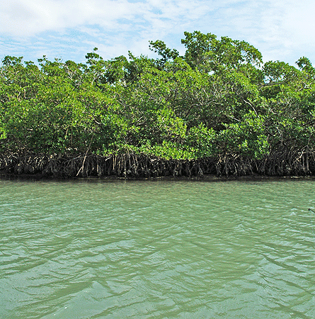 2)
Impact on Mangrove Organisms: Building these docks will adversely affect the conservation
of fish and wildlife, including endangered and threatened species,
and their habitats. Healthy mangrove estuaries are the nurseries of
game fish, shrimp, and crabs. Dredging will cause siltation and disturb
bottom sediments. Sea grasses, filter-feeding organisms like oysters,
and bottom dwelling crabs, sea stars, snails, and fish eggs will be
killed. Water current flow will be altered by the riprap. (Riprap
is a barrier made of rocks. Vanderbilt Partners II Ltd. proposes to
use riprap along some of the dock locations.) Pollution from leaks
and spills (petroleum, grease, and cleaning agents) will change the
chemistry of the channel. The chemical cycling will be altered, resulting
in both the degradation of the water quality and the degradation of the native mangrove
estuary community. Manatees that frequent the water will be unable
to reach sea grasses because of riprap and other dock barriers. The
building of the docks and the noise created by the increased human
activities along the mangrove banks will reduce optimal nesting sites
for birds. As has been proven in other watersheds such as Naples Bay,
“Only the most resilient species survive in waters altered by
development.”1
2)
Impact on Mangrove Organisms: Building these docks will adversely affect the conservation
of fish and wildlife, including endangered and threatened species,
and their habitats. Healthy mangrove estuaries are the nurseries of
game fish, shrimp, and crabs. Dredging will cause siltation and disturb
bottom sediments. Sea grasses, filter-feeding organisms like oysters,
and bottom dwelling crabs, sea stars, snails, and fish eggs will be
killed. Water current flow will be altered by the riprap. (Riprap
is a barrier made of rocks. Vanderbilt Partners II Ltd. proposes to
use riprap along some of the dock locations.) Pollution from leaks
and spills (petroleum, grease, and cleaning agents) will change the
chemistry of the channel. The chemical cycling will be altered, resulting
in both the degradation of the water quality and the degradation of the native mangrove
estuary community. Manatees that frequent the water will be unable
to reach sea grasses because of riprap and other dock barriers. The
building of the docks and the noise created by the increased human
activities along the mangrove banks will reduce optimal nesting sites
for birds. As has been proven in other watersheds such as Naples Bay,
“Only the most resilient species survive in waters altered by
development.”1
-
3) Im
 pact on Recreation:
Building these docks will adversely affect the fishing and recreational
values and marine productivity in the vicinity. Presently, kayakers,
canoers, and fishermen enjoy visiting the mangrove border of the
east shore of the Vanderbilt Channel. With 1/4 mile of docks built
from the 111th Street bridge to Water Turkey Bay, the opportunity
for recreational use by these groups will be eliminated. With siltation,
bottom degradation, and biochemical changes, it is likely that good
fishing opportunities will be eliminated throughout the channel.
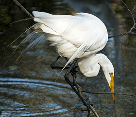
It is likely that many of the birds (osprey, eagles, ibis, pelicans,
yellow-crowned night herons, black-crowned night herons, and great
egrets) that frequent the area and attract photographers and nature
lovers, will leave.
pact on Recreation:
Building these docks will adversely affect the fishing and recreational
values and marine productivity in the vicinity. Presently, kayakers,
canoers, and fishermen enjoy visiting the mangrove border of the
east shore of the Vanderbilt Channel. With 1/4 mile of docks built
from the 111th Street bridge to Water Turkey Bay, the opportunity
for recreational use by these groups will be eliminated. With siltation,
bottom degradation, and biochemical changes, it is likely that good
fishing opportunities will be eliminated throughout the channel.
It is likely that many of the birds (osprey, eagles, ibis, pelicans,
yellow-crowned night herons, black-crowned night herons, and great
egrets) that frequent the area and attract photographers and nature
lovers, will leave.
-
4) Impact on Navigation: The present width of the channel is 251 feet at its widest point 2. With docks blocking one quarter of the channel 2, the remaining distance will be just 188 feet. The west bank of the river is presently used by fishermen and the channel is presently used by hundreds of boaters (power boats, canoes, kayaks, wave runners) whose only access to the Gulf is through this channel. Presently, most boaters stay in the middle of the channel when passing through. Some stop to fish along the mangroves along the eastern channel. With docks blocking one quarter of the channel, boaters will need to steer closer to the seawall on the west side of the channel where people are fishing from the sea wall. Lines, hooks, and props will likely affect safety of both boaters and fishermen. With constricted space in the channel, another safety issue occurs when two boats pass by one another or meet head-on.
-
5) Impact on Erosion: As more boats use the water close to the existing seawall on the west bank of the channel, there will be increased erosion from boat wake on the wall. This will result in costly repair charges to residents at Baker Carroll Point. Erosion will increase as a result of mangrove root disturbance on the east bank of the channel, which will add additional silt to the water.
-
6) Impact on Noise: The site preparation, assembly, repair, and use of 49 boat slips and a fishing pier will create noise pollution. Noise has been found to endanger the safety and health of people, and endanger real property. Pile drivers will be used to build the docks. The noise level of a pile driver is 110 decibels and is equivalent to a rock concert 3. Normal power boats reach levels of 90-105 dB 4. Cigarette boats are much louder. The noise of a boat at start-up is much louder than the idle speed of boats currently using this no-wake zone. Boats will be idling at the docks, generators will be going, and there will be parties at night. Sound is amplified over water 5. If docks are built, Gulf Breeze A will be just 275 feet and Surf Colony III will be just 350 feet from the closest docks. Dunes condos are located at much greater distances from the proposed dock locations and will have a thick wall of mangroves 6 to buffer the noise. The creation of loud noises is a detriment to the public health, comfort, safety, welfare and prosperity of the residents on the west bank of the channel. Hypertension and various psychological difficulties can be related to noise exposure 7. And, the level at which sustained exposure may result in hearing loss is 85 dB 8. Remember, pile drivers produce 110 decibels, normal boats 90-105, and cigarette boats are even louder.
- 7) Impact on Quality of Life and Property Value: The scenic view that attracted many of us to this area will be drastically altered if a 49-wetslip marina is constructed along the Vanderbilt Channel. Homeowners purchased property in this location because of the tranquil environment. Visitors rent these properties during season for the same reasons; they enjoy observing a quiet mangrove forest and the wildlife it attracts. The setting as it presently exists contributes to everyone's quality of life 9, (whether they live adjacent to the channel or boat along its shores), and the setting contributes to the monetary value of the property. With the building of a marina along this channel, quality of life and property value will likely suffer.
Left: The Vanderbilt Channel in April 2007.
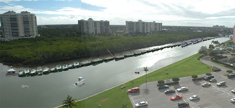
Left: The Vanderbilt Channel as it could appear with 49 docks and a
fishing pier.
In summary, if the Conservation Easement is counted in calculating the number of docks permitted in the marina:
- 49 wet slips will be constructed instead of 28
- Water quality will be further degraded by the marina construction, natural habitats will be destroyed, and wildlife will disappear.
- Navigation for the hundreds of boaters who use the channel will become more difficult.
- Recreational opportunities for others who desire to use the waterway will be more limited.
- THOUSANDS of families now and in the future will permanently lose access to this public water and the natural environment will be permanently damaged. The submerged land under all wet slips becomes Signature Communities property.9 In essence, public land will have been stolen from the public.
References:
1 "Time, progress not kind to Naples Bay", Naples Daily News, November 13, 2005.
2 Dunes Document Exhibit 2.3 F
3 "Sound Levels" by Frederico Miyara
4"Beating Noise" by Chris Caswell. The quote is “It isn’t unusual for inboard or stern drive boats to reach levels in the 90-105 dB range.”
5 "Why Sound/Noise Carries So Well Over Water" Howard Shaw, PhD, and Cheryl Jackson Hall, Ph.D.
6 These numbers were determined using the scale and drawing on Dunes Document Exhibit 2.3 F
7 "Ohio State University Fact Sheet ...Noise" by Jacqueline LaMuth: “In addition to contributing to hearing loss, too much noise can affect health in other ways too. There are immediate effects that may be temporary or may become longer lasting. These include cardiovascular problems with an accelerated heartbeat and high blood pressure, gastric-intestinal problems, a decrease in alertness and ability to memorize, nervousness, pupil dilation and a decrease in the visual field. Effects that my be longer lasting include insomnia, nervousness, bulimia, chronically high blood pressure, anxiety, depression and sexual dysfunction.”
8 Information Center: Hearing Loss
9 Greenbelt Alliance“: "No one has an absolute right to use his or her land in a way that may harm the public health or welfare, or that damages the quality of life of neighboring landowners, or of the community as a whole.”********************************************************
To read the time line of the history of the Dunes Dock Issue and read Naples Daily News articles pertaining to the subject, go to Link to History of Dunes Dock Issue
********************************************************